Crisis before the Six Day War
In May and early June of 1967, tensions between Israel and the surrounding states built to a crisis.
Read More
In May and early June of 1967, tensions between Israel and the surrounding states built to a crisis.
Read MoreAt the end of the War of Independence, Jerusalem was divided between Israel and Jordan. Armistice lines were determined in November 1948 by Moshe Dayan, Israeli Commander of the Jerusalem district, and Abdallah el-Tal, Legion Commander of Jordan’s Jerusalem front. Between the lines drawn by the two commanders, areas left undefined became “no-man’s land.” The area around Armon Hanatziv was used as UN territory, and Mount Scopus became an Israeli enclave containing the Hebrew University, Hadassah Hospital and, officially, the village of Issawiyya. This map was adopted in April 1949 in an armistice agreement signed in Rhodes. The westernmost point between the two parts of the city was at the edge of the Musrara neighborhood, near the Mandelbaum Gate.
Read MoreIn 1947, Great Britain turned over Mandatory Palestine to UN responsibility. The General Assembly appointed a committee which after much study and discussion recommended partitioning the land into Jewish state and Arab states, with Jerusalem under international supervision. On November 29, the partition resolution was accepted by a vote of 33-13.
Read More


 Netanyahu offers to fire Edelstein for haredi parties staying in coalitionNetanyahu offers to fire Edelstein for haredi parties staying in coalition
 IDF soldier hospitalized after apparently suffering self-inflicted gunshot wound
 Huckabee: Probe ‘terrorist’ killing of Palestinian American in West Bank
 New Gaza withdrawal maps secure progress in ceasefire talks; Chief of Staff presents IDF withdrawal plan
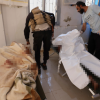 Syrian regime forces executed Druze civilians, reports say: ‘Adopted brutal tactics’
 US ambassador demands probe into killing of Palestinian American man: ‘Terrorist act’
 CNN journalist attacked by settlers near Ramallah: ‘Car window smashed – managed to escape unharmed’
 Lebanon’s Central Bank shuts down financial pipeline to Hezbollah
 Zvi Yehezkeli: Julani proves he’s unworthy – the ISIS DNA is stronger
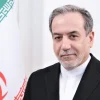 Europe gives Iran August deadline for ‘snapback’ sanctions
 Draft Law crisis | Haredi parties: Edelstein has deceived us
 ISRAEL21c’s Next Phase
 12 impossible ideas that Israelis turned into reality
 Why some think the new ‘Superman’ movie is about the war in Gaza – OpinionLebanon’s Central Bank shuts down financial pipeline to Hezbollah
 Are Shas and UTJ poised to collapse Netanyahu’s government?